Geophysics in Saguenay encompasses a suite of non-invasive subsurface investigation techniques designed to map geological structures, assess material properties, and identify potential hazards without the need for extensive excavation. In a region shaped by glacial and tectonic forces, these methods are critical for understanding the complex stratigraphy of marine clays, till deposits, and fractured bedrock that characterize the Saguenay Graben. By measuring variations in physical properties such as seismic velocity, electrical resistivity, and electromagnetic response, geophysical surveys offer continuous subsurface profiles that complement traditional borehole data, reducing uncertainty in ground models and supporting safer, more cost-effective engineering decisions.
The Saguenay region presents unique geotechnical challenges rooted in its Quaternary history and seismotectonic setting. The area is underlain by the sensitive Laflamme Sea clays, which are prone to retrogressive landslides, and is crossed by the Saguenay Graben, a seismically active fault system that produced the 1988 magnitude 5.9 earthquake. Glacial overconsolidation has left stiff clays over softer sediments, creating sharp velocity and resistivity contrasts that are ideal targets for geophysical detection. Additionally, bedrock topography is highly irregular, with deep buried valleys filled with coarse glaciofluvial deposits. These conditions demand high-resolution imaging to delineate bedrock depth, identify weak zones, and characterize the dynamic properties of soils for seismic site classification.
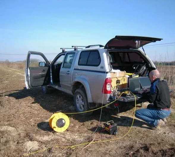
Seismic site classification in Canada is governed by the National Building Code of Canada (NBC), which requires the determination of the average shear-wave velocity in the upper 30 metres (Vs30) for Site Class assignment. In Saguenay, where seismic hazard is non-negligible due to the Charlevoix-Kamouraska seismic zone, accurate Vs30 values are essential for structural design. MASW / Vs30 (shear wave velocity) surveys are the standard method for obtaining these profiles, providing a direct measurement of small-strain stiffness that correlates with liquefaction resistance and ground amplification potential. The NBC tables and the Canadian Foundation Engineering Manual recognize such geophysical methods as valid means of site investigation, provided they are calibrated with local geological knowledge.
Geophysical investigations in Saguenay are mandated or strongly recommended for a wide range of infrastructure and development projects. Transportation corridors crossing the clay plains require bedrock mapping for bridge foundations and cut slope stability assessments. Municipal and industrial building projects on thick post-glacial sediments rely on shear-wave velocity profiling to comply with seismic design provisions. Seismic tomography (refraction/reflection) is particularly valuable for delineating the bedrock surface beneath variable overburden, mapping fracture zones within the Precambrian shield rocks, and identifying paleochannels that may affect groundwater flow or excavation stability. Environmental site assessments and landslide hazard mapping also employ electrical and electromagnetic methods to image the saline porewater interface in sensitive clays, a key factor in slope stability analysis.
The most common methods include MASW for shear-wave velocity profiling and seismic site classification, seismic refraction and reflection tomography for bedrock mapping, electrical resistivity imaging for mapping sensitive clays and groundwater, and ground penetrating radar for shallow utility and stratigraphic surveys. The choice depends on target depth, required resolution, and the specific geological conditions such as the presence of conductive Laflamme Sea clays.
The 1988 magnitude 5.9 earthquake highlighted the seismic activity of the Saguenay Graben and led to stricter seismic hazard considerations in the National Building Code of Canada. As a result, accurate determination of Vs30 via geophysical methods is now essential for Site Class assignment, influencing foundation design and structural reinforcement requirements for new buildings and critical infrastructure in the region.
The region's sensitive marine clays are prone to large retrogressive landslides, while buried bedrock valleys and fractured shield rocks create abrupt lateral changes in ground conditions. These features are difficult to fully characterize with boreholes alone. Geophysics provides continuous profiles that map clay thickness, detect fractures and weak zones, and image bedrock topography, which is essential for slope stability and foundation design.
The National Building Code of Canada (NBC) references shear-wave velocity measurements for seismic site classification. The Canadian Foundation Engineering Manual provides guidance on geophysical method selection and interpretation. While no single CSA standard covers all geophysical methods, ASTM International standards such as ASTM D5777 for seismic refraction and ASTM D6431 for resistivity are commonly specified in Canadian practice.
We serve projects across Saguenay and its metropolitan area.